
What You Need to Know: The 6-day Machame suits fit hikers with recent high-altitude experience who are short of time. It costs from US$1,845 per person (2 climbers, mid-range hotels), with 5 nights in tents, the Lava Tower acclimatization day, and one long day from Barranco over the Barranco Wall to Barafu before summit night. If this is your first high mountain, the 7-day Machame adds a night at Karanga for US$245 more.
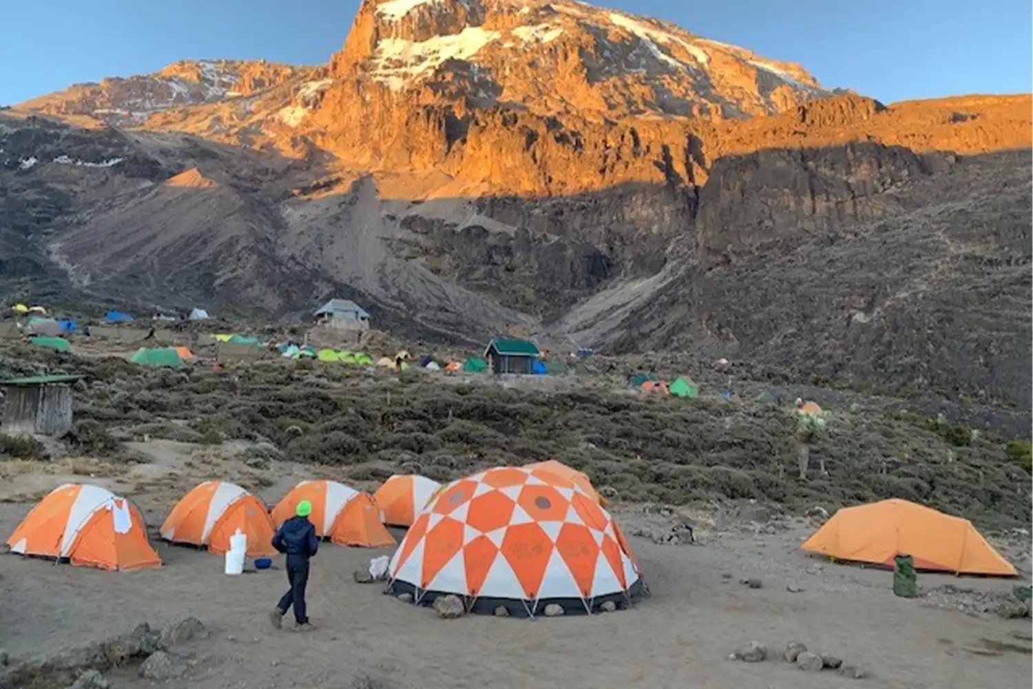
Is the 6-Day Machame Climb Right for You?
It is the right climb if you are fit, have been above 14,800 ft (4,500 m) in the last year or so and felt well, and can only give the mountain six days. It is not the right climb for a first high mountain: the 7-day version costs a little more and gives you an extra night to adjust exactly where it helps most.
Machame is sometimes called the 'Whiskey Route', because it is steeper and more varied than Marangu. In six days you cross five climate zones and sleep in tents at five camps.
| The 6-day Machame suits you if… | Consider another climb if… |
|---|---|
| You have been to high altitude recently and felt well | This is your first climb above 13,100 ft (4,000 m): the 7-day Machame |
| You are fit and short of time | You want quieter trails and the most gradual ascent: the 8-day Lemosho |
| You want a varied camping route | You would rather sleep in huts: the 6-day Marangu |
| You can manage a 7–8 hour day before summit night | You are climbing in the rainy months: the Rongai route |
Should You Choose Six Days or Seven?
Choose six days if you are fit, have trekked at altitude before and are short of time. Choose seven if this is your first high mountain.
The difference is one night. On the 6-day climb, Day 4 runs from Barranco Camp over the Barranco Wall all the way to Barafu Camp at 15,354 ft (4,680 m): about 6 miles (9 km) and 7–8 hours, followed a few hours later by the summit push. The 7-day climb splits that day with a night at Karanga Camp (13,238 ft / 4,035 m), so you arrive at Barafu rested.
Kilimanjaro National Park records from the early 2000s showed 44% of climbers reaching the summit on 6-day climbs and 64% on 7-day climbs, across all routes. Today's rates are higher, but the gap is still the reason we recommend seven days to first-timers. On our prices the extra day costs US$245 per person.
The 6-Day Machame Route at a Glance
Machame Gate – Machame Camp – Shira Camp – Lava Tower – Barranco Camp – Barafu Camp – Uhuru Peak – Mweka Camp – Mweka Gate.
You go up the south-west side and come down the south-east on the Mweka trail.
| Day | Sleep at | Altitude | Walking time |
|---|---|---|---|
| 1 | Machame Camp | 10,007 ft (3,050 m) | 5–6 hours |
| 2 | Shira Camp | 12,631 ft (3,850 m) | 4–5 hours |
| 3 | Barranco Camp (via Lava Tower, about 15,100 ft / 4,600 m) | About 13,000 ft (3,960 m) | 6–8 hours |
| 4 | Barafu Camp | 15,354 ft (4,680 m) | 7–8 hours |
| 5 | Mweka Camp (via Uhuru Peak, 19,341 ft / 5,895 m) | 10,138 ft (3,090 m) | 10–14 hours |
| 6 | Hotel in Moshi (via Mweka Gate, 5,512 ft / 1,680 m) | — | 3–4 hours |
6-Day Machame Itinerary: Why Each Day Matters
Two days lift you out of the forest onto the Shira Plateau, Day 3 trains your body for altitude at Lava Tower, Day 4 is the long push to Barafu, and summit night follows.
-
Day 1: Machame Gate (6,004 ft / 1,830 m) to Machame Camp (10,007 ft / 3,050 m)
About an hour's drive (22 miles / 35 km) from Moshi to Machame Gate, where your guide registers the climb and the porters weigh their loads. Then 5–6 hours on a winding forest trail up a ridge. The lower trail is often muddy and slippery, so gaiters and trekking poles help.
Walk slower than feels necessary; pole pole, 'slowly, slowly', is the rule from the first hour. Your tent is up when you reach camp at the edge of the forest.
Purpose: an easy start; leave the forestRainforestLunch, dinner -
Day 2: Machame Camp to Shira Camp (12,631 ft / 3,850 m)
About 3 miles (5 km) and 4–5 hours. You leave the forest for open moorland, cross valleys and steep ridges, and head west onto the Shira Plateau, with the first views across to Kibo's glaciers.
A shorter day that gives your body time to rest at a new altitude. A short walk above camp before dinner helps.
Purpose: gain height gentlyHeath and moorlandBreakfast, lunch, dinner -
Day 3: Shira Camp to Lava Tower and down to Barranco Camp (about 13,000 ft / 3,960 m)
About 6 miles (10 km) and 6–8 hours across semi-desert. You climb to Lava Tower, around 15,100 ft (4,600 m), and then descend to Barranco. You sleep at almost the same height you woke at, but the time spent higher up is what helps you acclimatize.
Expect a headache at Lava Tower. Tell your guide if it doesn't ease on the way down.
Purpose: climb high, sleep lowAlpine desertBreakfast, lunch, dinner -
Day 4: Barranco Camp to Barafu Camp (15,354 ft / 4,680 m)
About 6 miles (9 km) and 7–8 hours, the longest day before the summit. It starts with the Barranco Wall, an 820 ft (250 m) scramble where you use your hands in places, then crosses ridges and valleys past Karanga to Barafu Camp.
Dinner is early, with the summit briefing, a health check and a gear check, and you sleep for a few hours before the summit attempt. This is the day the 7-day climb splits in two.
Purpose: reach the summit base campAlpine desertBreakfast, lunch, dinner -
Day 5: Barafu Camp to Uhuru Peak (19,341 ft / 5,895 m), then down to Mweka Camp (10,138 ft / 3,090 m)
You set off around midnight by headlamp, reach Stella Point on the crater rim around sunrise, then walk on to Uhuru Peak. After the summit you come back to Barafu to rest and eat, and continue down to Mweka Camp: about 11 miles (17 km) and 10–14 hours in total. The next section explains the night step by step.
Purpose: the summitArctic summit zoneSnacks, lunch, dinner -
Day 6: Mweka Camp to Mweka Gate (5,512 ft / 1,680 m), drive to Moshi
About 6 miles (10 km) and 3–4 hours down through the rainforest. Summit certificates are issued at the gate, where most climbers thank and tip the crew, and we drive you back to your hotel in Moshi.
Purpose: descend; certificatesRainforestBreakfast
How Hard Is the 6-Day Machame Climb?
It is a hard trek, but not a technical climb. On six days the altitude comes faster than on our longer climbs, and Day 4 is long.
| Challenge | What it means for you |
|---|---|
| Altitude | Less time to adjust than on 7 or 8 days; the main reason we ask about your altitude experience |
| Day 4 | About 6 miles (9 km) and 7–8 hours, then summit night a few hours later |
| Summit night | 6–8 hours uphill in the dark and cold, then 6–8 hours down |
| Barranco Wall | An 820 ft (250 m) scramble with hands in places, not technical |
| Camping | Five nights in tents, near or below freezing at the higher camps |
Your Kilimanjaro Guide, Crew and Food
Every climber on our Kilimanjaro climbs has a crew of seven: one mountain guide, one cook and five porters. For two climbers that is a crew of 14 for all 6 days. The crew carries the tents, sleeping mats, a mess tent with table and chairs, a private portable toilet tent for your group, the food, water and the safety kit, so you carry only a daypack with water, snacks, layers and a camera.
Food on the mountain
How Much Does the 6-Day Machame Climb Cost?
The 6-day Machame climb costs from US$1,845 per person for 2 climbers with mid-range hotels in Moshi. Budget hotels bring it to US$1,675, and luxury hotels to US$1,990. The price is for a private climb on your own dates; budget, mid-range or luxury changes only your two hotel nights in Moshi.
| Climbers | Budget | Mid-range | Luxury |
|---|---|---|---|
| 1 | US$1,700 | US$1,890 | US$2,080 |
| 2 | US$1,675 | US$1,845 | US$1,990 |
| 3 | US$1,680 | US$1,880 | US$1,980 |
| 4 | US$1,675 | US$1,845 | US$1,990 |
| 5 | US$1,675 | US$1,865 | US$1,985 |
| 6 | US$1,675 | US$1,845 | US$1,990 |
Where the money goes
About half the price is Kilimanjaro National Park fees, which every operator pays at the same rate. For 6 days on the mountain the 2026 non-resident fees come to:
| Park fee (per climber) | Rate | 6-day Machame |
|---|---|---|
| Conservation fee | US$70 per day | US$420 |
| Camping fee | US$50 per night | US$250 |
| Rescue fee | US$20 per climb | US$20 |
| VAT | 18% | US$124 |
| Total park fees | About US$814 |
What the 6-Day Machame Price Includes, and What It Doesn't
Included
- Kilimanjaro National Park fees, VAT and trekking permits
- A crew of seven per climber: mountain guide, cook and five porters
- Tents, sleeping mats, mess tent with table and chairs, and a private portable toilet tent
- All meals on the mountain, drinking water and hot drinks
- First-aid kit, emergency oxygen, pulse oximeter and stretcher
- Return airport transfers, and transfers to Machame Gate and from Mweka Gate
- One hotel night in Moshi before and one after the climb
Not included
- International and domestic flights, and visa fees (US$100 for US citizens)
- Tanzania's mandatory inbound travel insurance, US$44 per adult from October 1, 2026 (we can help you buy it)
- Travel insurance that covers trekking up to 19,700 ft (6,000 m) and helicopter evacuation
- Personal climbing gear (rental available in Moshi)
- Tips for the mountain crew (tipping guide)
- Meals and activities in Moshi, drinks, laundry and personal items
- The card-processing fee when you pay the deposit online
Tips to budget for
Using the daily ranges in our tipping guide, US$20–30 for the guide, US$10–15 for the cook and US$5–10 for each porter, a crew of seven for 6 days comes to about US$330–570 per climber, given at the end of the climb.
When Is the Best Time for the Machame Route?
Late May to October and January to March. We don't recommend April, early May, November or the late-December holiday period. The southern and western routes are the wettest side of the mountain, so in the long rains the forest trail turns to deep mud and wet gear makes the high camps much colder. July to September brings the clearest skies and the most climbers; January to March is a little warmer and quieter.
| Months | Our advice |
|---|---|
| January – March | Recommended: warmer, quieter |
| April – early May | Not recommended: long rains |
| Late May – October | Recommended: dry season, busiest months |
| November | Not recommended: short rains |
| Late December | Not recommended: holiday crowds |
6-Day Machame Compared with the 7-Day Machame and 6-Day Marangu
These are the climbs people most often weigh against the 6-day Machame.
| 6-day Machame | 7-day Machame | 6-day Marangu | |
|---|---|---|---|
| Nights on the mountain | 5 in tents | 6 in tents | 5 in huts |
| Barranco to Barafu | One day, 7–8 hours | Two short days | — |
| Acclimatization aid | Lava Tower | Lava Tower + Karanga | Extra day at Horombo |
| Best for | Fit hikers with altitude experience | Most first-timers | Climbers who would rather not camp |
| Price from (2 climbers, mid-range) | US$1,845 | US$2,090 | US$1,845 |
Full itineraries: the 7-day Machame and the 6-day Marangu. Prefer to climb with others? The 6-day Machame has 2027 group departures on June 12 and June 29.
What Else to Read Before You Book
This page covers what is particular to the 6-Day Kilimanjaro Climb via the Machame Route. The parts that work the same way on our other trips are explained once, in these guides:
- How hard is Kilimanjaro?: summit night, fitness and training.
- Kilimanjaro acclimatization: altitude sickness symptoms and how our guides check you at every camp.
- Kilimanjaro packing list: everything to bring, layer by layer.
- Rental gear in Moshi: what you can rent and the price for the whole climb.
- Where to sleep before and after the climb: hotels in Moshi and the nights included.
- Kilimanjaro booking and refund terms: deposit, balance and cancellation.
- Tipping your Kilimanjaro crew: suggested amounts per climber and how the crew shares them.
Common Questions About the 6-Day Machame Climb
Is six days enough to acclimatize on Kilimanjaro?
For fit hikers who have been at altitude before, often yes. The Lava Tower day helps a lot. But six days gives less time to adjust than seven, so first-time high-altitude trekkers should consider the 7-day Machame.
What happens if you feel unwell during the climb?
Tell your guide straight away. Your health is checked at every camp with a pulse oximeter. If it is unsafe to continue, the guide arranges your descent, and emergency oxygen and a stretcher are carried on every climb.
Do you need climbing experience for the Machame Route?
No technical climbing is needed. The Barranco Wall is a scramble where you use your hands in places. You do need good fitness for several long days in a row and a 10–14 hour summit day.
Can I join a group on the 6-day Machame?
Yes. Our 2027 group departures on the 6-day Machame start on June 12 and June 29, at the same per-person price as a private climb. See our Kilimanjaro group climbs.
The Bottom Line
If you are fit, short of time and have been to high altitude recently, the 6-day Machame gives you Kilimanjaro's most varied camping route in six days. If this is your first high mountain, spend the extra US$245 on the 7-day Machame: the night at Karanga is the single most useful change you can make.
To plan your climb, send us your preferred dates, the number of climbers and your hotel level (budget, mid-range or luxury) through the booking form, on WhatsApp +255 678 992 599 or by email to jaynevytours@gmail.com. Our sales team in Moshi will confirm availability and send your written quotation.