Kilimanjaro in Tanzania Map – Location, Routes, and Travel Guide
If you’re planning to visit Tanzania or climb Africa’s highest peak, you’ve probably wondered, “Where is Kilimanjaro in Tanzania on the map?” This guide provides a detailed explanation of Mount Kilimanjaro’s location, nearby towns, routes on the mountain map, and how to get there from other parts of Tanzania. We’ll also include tips for climbers and travelers exploring this iconic natural wonder.
1. Where Is Mount Kilimanjaro Located in Tanzania?
Mount Kilimanjaro is located in northeastern Tanzania, near the border with Kenya. It sits within the Kilimanjaro Region and is part of the Kilimanjaro National Park, a UNESCO World Heritage Site. The mountain is approximately 5,895 meters (19,341 feet) above sea level — making it the tallest mountain in Africa and the highest free-standing mountain in the world.
On the map, Kilimanjaro is situated about 50 kilometers east of Arusha and 80 kilometers south of the Kenya-Tanzania border. Its exact coordinates are approximately 3.0674° S latitude and 37.3556° E longitude.
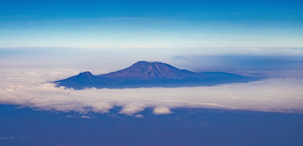
2. Kilimanjaro on the Map of Tanzania
On the Tanzania map, Mount Kilimanjaro lies in the northern part of the country — between Moshi and Arusha. This region is one of Tanzania’s top travel destinations because of its proximity to national parks like Serengeti, Ngorongoro, Lake Manyara, and Tarangire.
The map shows the Kilimanjaro massif surrounded by lush farmland, forests, and small villages that serve as gateways for climbers.
- To the west: Arusha city and Mount Meru
- To the south: Moshi town – the main base for Kilimanjaro treks
- To the north: The Kenya border and Amboseli National Park
- To the east: Pare Mountains and Same District
3. Map of Kilimanjaro National Park
Kilimanjaro National Park covers an area of about 1,688 square kilometers. It includes the mountain itself and the surrounding forest reserve. The map of Kilimanjaro National Park displays several trekking routes, campsites, and entry gates.
- Marangu Route: Easiest and most popular path, also called the “Coca-Cola Route.”
- Machame Route: Known as the “Whiskey Route” for its scenic beauty and moderate challenge.
- Lemosho Route: Long and scenic, ideal for gradual acclimatization.
- Rongai Route: Approaches the mountain from the north near Kenya.
- Umbwe Route: Steep and direct, recommended for experienced climbers.
- Shira Route: Connects with Lemosho and offers stunning western views.
On the Kilimanjaro map, these routes converge near the summit area — known as Uhuru Peak — located on the Kibo cone. The other two volcanic cones are Mawenzi and Shira.
4. Nearby Towns and Cities Around Kilimanjaro
The two main towns shown near Mount Kilimanjaro on the map are:
- Moshi: The closest town to Kilimanjaro National Park (about 45 minutes to Marangu Gate).
- Arusha: About 80 km away — the safari capital and base for many tour operators.
Both towns have good infrastructure, accommodations, and transport options for travelers heading to Kilimanjaro or the northern safari circuit.
5. How to Get to Kilimanjaro
The easiest way to reach Kilimanjaro is by air through Kilimanjaro International Airport (JRO), located between Arusha and Moshi. The airport receives flights from Dar es Salaam, Nairobi, Addis Ababa, Doha, Dubai, and Amsterdam.
- From Arusha to Moshi: 80 km (1.5 hours by road)
- From Dar es Salaam to Moshi: 550 km (9–10 hours by bus or 1-hour flight)
- From Nairobi, Kenya: 370 km (5–6 hours by road)
6. Understanding the Kilimanjaro Map – Key Zones
Mount Kilimanjaro’s map shows five distinct climate zones from base to summit:
- Cultivation Zone (800–1,800 m): Fertile farmland with coffee and banana plantations.
- Montane Forest (1,800–2,800 m): Dense tropical forest and wildlife habitat.
- Heather and Moorland (2,800–4,000 m): Shrubs, heather, and cool air.
- Alpine Desert (4,000–5,000 m): Dry, rocky terrain with sparse vegetation.
- Arctic Summit Zone (Above 5,000 m): Ice, snow, and glaciers leading to Uhuru Peak.
These zones are clearly visible on detailed topographic maps of Kilimanjaro, showing the mountain’s elevation and trekking routes.
7. Travel Tips for Visiting Kilimanjaro in Tanzania
- Always use official park gates such as Marangu, Machame, or Lemosho for entry.
- Hire a licensed guide through an approved tour operator.
- Acclimatize properly by choosing longer routes (7–8 days) for safety.
- Carry warm gear – temperatures drop significantly at high altitudes.
- Respect the mountain’s environment; avoid littering and follow park regulations.
8. Why Visit Kilimanjaro?
Kilimanjaro isn’t just a mountain — it’s a symbol of Africa’s natural beauty and strength. On the Tanzania map, it stands proudly near the equator, surrounded by safari parks, waterfalls, and cultural villages. Whether you climb to the summit or admire it from below, Kilimanjaro offers an unforgettable experience.
9. Summary – Kilimanjaro in Tanzania Map
In summary, Mount Kilimanjaro is located in northern Tanzania, close to Moshi and Arusha, and near the Kenya border. On the map, it’s easy to spot as a massive volcanic peak dominating the region. The mountain can be accessed through several trekking routes inside Kilimanjaro National Park, with Kilimanjaro International Airport serving as the main entry point.
For detailed maps, guided climbs, and Tanzania travel packages, visit www.jaynevytours.com.