How Big is Tanzania – Complete Guide 2026
Tanzania is one of the largest countries in Africa, known for its vast landscapes, diverse ecosystems, and rich cultural heritage. Understanding how big Tanzania is helps travelers, researchers, and investors appreciate its geography, population, and natural resources. This guide covers Tanzania’s total area, regional divisions, population distribution, and key geographical features.
1. Total Area of Tanzania
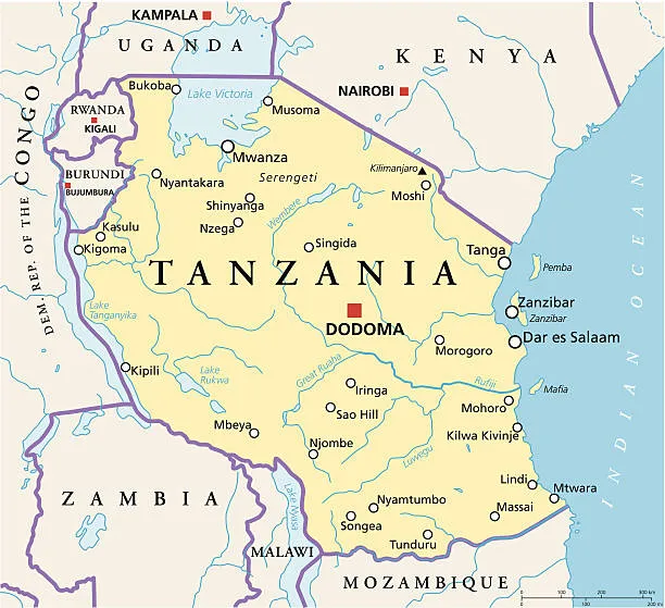
Tanzania covers a total area of approximately 947,303 square kilometers (365,756 square miles). This makes it the 13th largest country in Africa and one of the largest in East Africa . The country’s size allows for diverse landscapes, from mountains and savannahs to lakes and coastal areas.
2. Tanzania’s Borders
Tanzania shares borders with eight countries and the Indian Ocean:
- North: Kenya and Uganda
- West: Rwanda, Burundi, and Democratic Republic of Congo (via Lake Tanganyika)
- South: Zambia , Malawi, and Mozambique
- East: Indian Ocean coastline
These borders contribute to Tanzania’s strategic location for trade, tourism, and regional cooperation.
3. Population and Density
Tanzania has a population of approximately 65 million people (2026 estimate). With its large area, the population density is relatively low, averaging around 69 people per square kilometer. Population distribution varies, with higher densities in urban centers such as Dar es Salaam, Arusha, and Mwanza, while rural areas remain sparsely populated.
4. Major Geographical Features
Tanzania’s large size encompasses diverse geographical features:
- Mountains: Mount Kilimanjaro (Africa’s highest peak) and the Usambara and Uluguru ranges.
- Lakes: Lake Victoria , Lake Tanganyika, and Lake Nyasa provide water resources and fishing opportunities.
- National Parks: Serengeti, Ngorongoro Crater , Selous Game Reserve, and Ruaha support wildlife and tourism.
- Coastal Areas: Indian Ocean coastline with sandy beaches and ports such as Dar es Salaam and Tanga.
5. Administrative Divisions
Tanzania is divided into 31 regions (mkoa), each with its own administrative capital. Some of the largest regions by area include:
- Tabora
- Dodoma
- Rukwa
- Morogoro
Each region is further divided into districts and wards to facilitate governance and development planning.
6. Travel and Exploration
Tanzania’s large size offers diverse travel opportunities:
- Wildlife safaris across northern and southern circuits.
- Mountain climbing on Kilimanjaro and other highlands.
- Beach holidays on Zanzibar and the Tanzanian coast.
- Exploration of lakes, forests, and cultural heritage sites.
7. Summary – How Big is Tanzania
Tanzania covers approximately 947,303 square kilometers, making it one of Africa’s largest countries. Its vast size supports diverse ecosystems, abundant wildlife, major lakes, mountains, and extensive coastlines. Understanding how big Tanzania is helps travelers, investors, and researchers appreciate its geographical and economic potential. With its large area, low population density, and rich natural resources, Tanzania remains a key destination for tourism, agriculture, and investment in East Africa.
For more guides on Tanzania’s geography, travel, and culture, visit www.jaynevytours.com.